Grid Mapping Starter Kit 🌱
A starter kit for Electrical Transmission Grid Mapping in OpenStreetMap, combining Osmose and Overpass with JOSM. The tutorial for mapping using JOSM starts with "Install JOSM".
Get started with OpenStreetMap and Open Infrastructure Map 🗺️
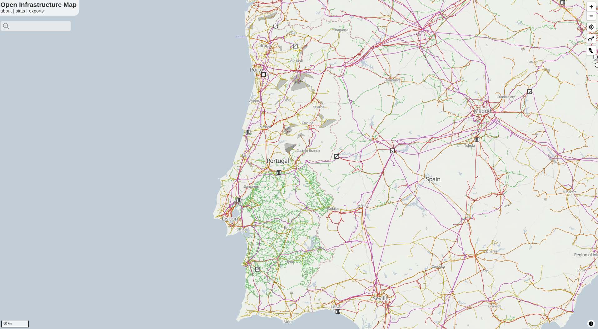
If you don't already have an OpenStreetMap account, create one first. If you're new to OpenStreetMap, now is a good time to learn the basics of editing using the in-browser editor (iD) - find something which is missing from the map in your local area and add it! The OpenStreetMap Wiki has lots of information about how to map with OpenStreetMap, and you can start by reading the iD Beginners' Guide. Adding missing power towers or substations can significantly improve mapping progress, as it gives other mappers a clue as to where parts of the entire grid are missing. To quickly check if anything is missing near you, go to the Open Infrastructure Map. Press the 'Find my location' button in the top right corner or enter your town in the search box. See something missing next to you? Map it using your iD editor. Don't worry about making mistakes. Mapping is an iterative process, and the OpenStreetMap community automatically detects anything that is missing. The OpenStreetMap Wiki pages The Power Network and Key:Power provide an overview of how to map different power infrastructure.
⚠️ Before you start mapping, please find out about the mapping restrictions in the respective country. In some countries, the mapping of transmission lines is not permitted. Get in touch with local users by finding out about local projects. ⚠️
Install JOSM 
JOSM is a more advanced desktop OpenStreetMap editor which is more suitable for power grid mapping.
Note
The JOSM Preferences window is accessed through the Edit → Preferences menu on Windows and Linux, and JOSM → Settings on Mac.
- Install Java on your device if not installed.
- Install JOSM on your device (if needed, further instructions on how to install and use JOSM on your device can be found at learnOSM).
- (Optional) If you want preconfigured preferences, download this preferences.xml file and paste it in the correct folder on your device. The JOSM wiki provides details on where to place it.
- Download this template session, and in JOSM go to File>Open and open the .joz file.
- Create an OSM account if you don't have one. Once you do, go to
Preferences → OSM Serverand press authorise now. Login with your OSM account, and authorise. Your account is now linked to JOSM on your device. Be aware that your token will be stored in your local preferences.xml file. Do not share your preferences file with anyone.
 - Finally, activate "expert mode" in
View → Expert mode. This will enable using Overpass API. - Make sure remote control is enabled in
Preferences → Remote Control. This must be activated for the grid data to be loaded automatically.
Coloring your grid map and legend 🎨
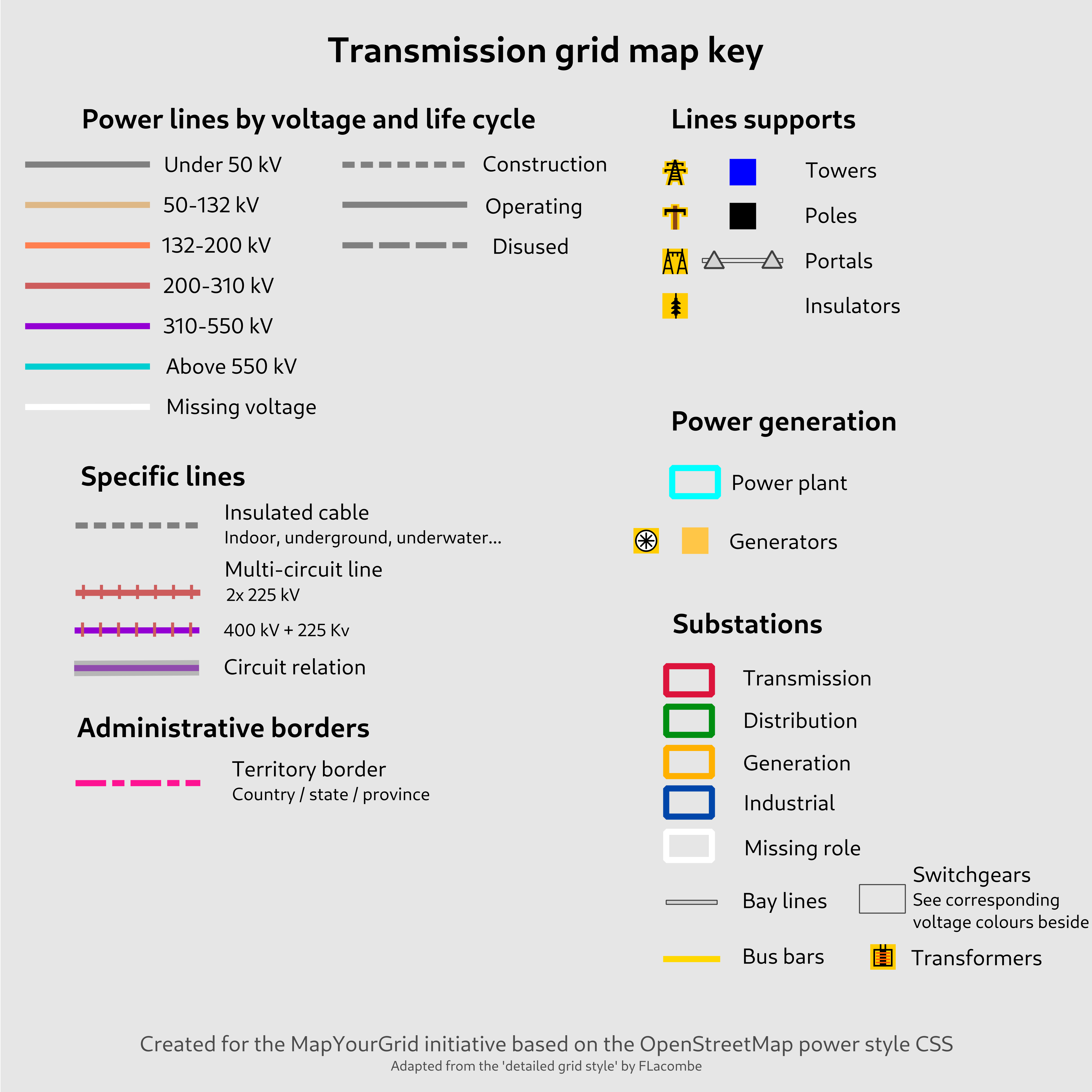
-
To add our custom paint style to JOSM, go to
Preferences → Map Paint Stylesand press the "+" in the top right. Then you can paste this URL. If this does not work, you can also download the raw file on your device, and add it. -
(Optional) We recommend using this MapCSS file for low-density grids and this one for high-density grids.
- You can use ColorMyGrid, our MapCSS Generator tool, to easily adapt the MapCSS file to fit any special requirements you might have.
- In the ColorMyGrid repo you will also find the raw data to edit the map legend.
Loading power infrastructure into JOSM 
- Make sure remote control is enabled and ad-blocker disabled, and then go to the start mapping page. Here you can click on the country you want to map, and it will directly open JOSM and load the data of that country. Use the "Default Transmission (90kV+)" to pull the data.
How to Map and upload your progress 
Mapping is an iterative process, so you will make mistakes at first. However, this should not stop you from mapping; simply map what you can verify based on your skillset. If a tower, lines or key are missing, our quality assurance tool Osmose will automatically detect this.

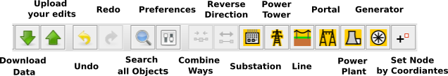
- For ease of mapping, customise your top toolbar with presets if you have not used the default preferences. Right click the toolbar and choose
Configure toolbar, then selectPresets → Man Made → Man Made/Powerand add power towers, power portals and other presets for your mapping acticity. - Start Mapping. Read more about the general mapping process in JOSM. Place nodes (eg. power towers, power portals) or place polygons to delimit an area (eg. substation, generator), and press on the preset structure you want it to be.
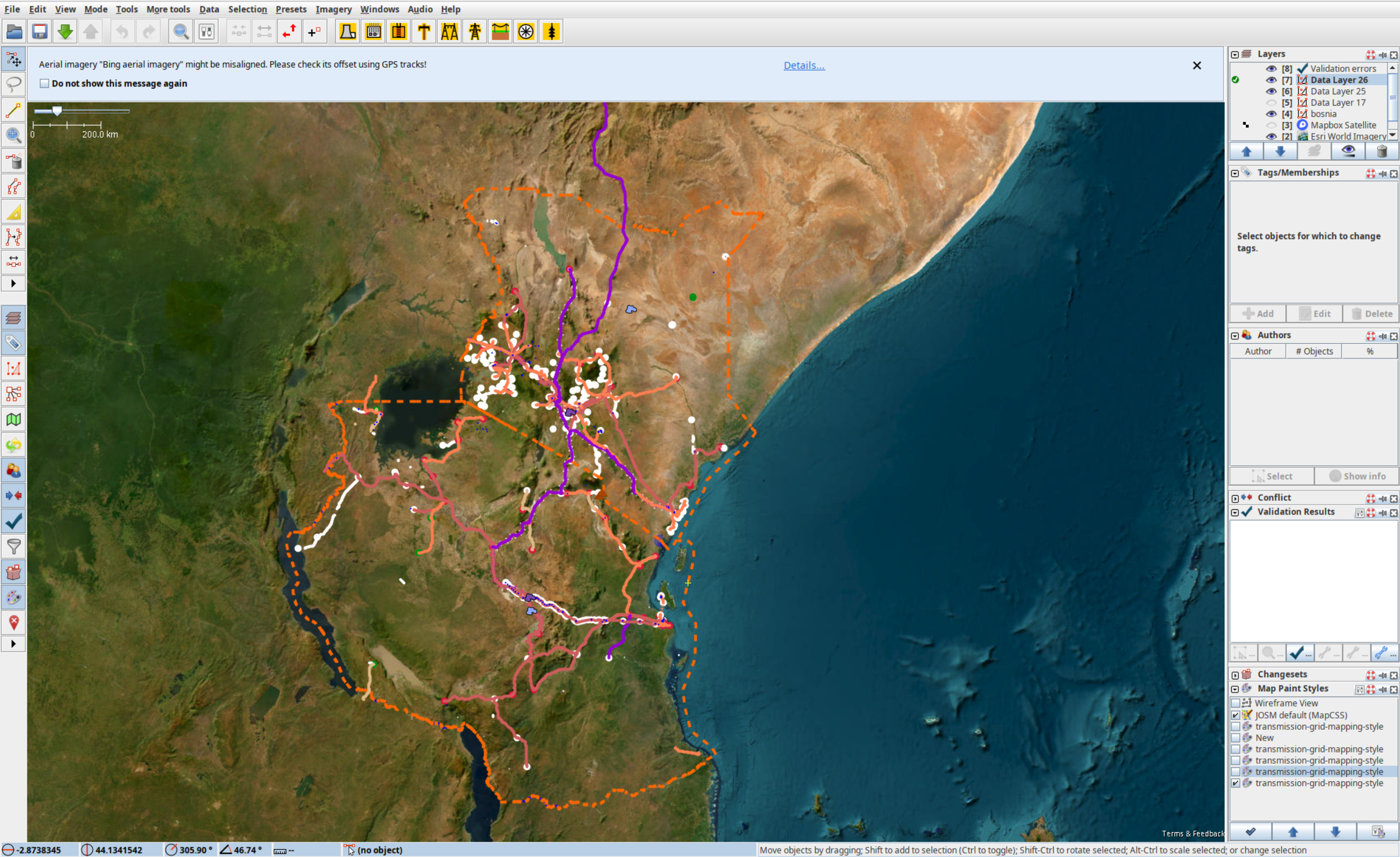
 Example: As seen in the image, the red polygon is a substation which is mapped by adding nodes that are connected to each other and tagged as a substation.
 - Whilst having the OpenStreetMap layer activated, press the green Upload arrow. Avoid ignoring validation results. The only acceptable warning when uploading data is "Possible missing line support node within power line". When you make an edit, please use the #ohmygrid in the changeset to help the initiative!
Unfinished lines with Osmose and the todo Plugin ✅

- Download the Unfinished Power Transmission lines (Class 2) via Osmose for your country.
- Drag and drop the downloaded geojson file into JSOM.
- Download the todo plugin for JSOM. Edit --> Preferences. Search for todo, mark it and press OK. Press Windows --> todo list to show the Todo list window.
- Press STRG+A (CTRL + A or COMMAND + A) to select all issues in the new layer. Press the Add in the todo plugin window (
Windows → Todo list) - Switch back to the OSM data layer.
- You can now systematically step through all the issues by pressing Mark.
Map fast 

If you want to be able to map efficiently and fast, you will need to know how to correctly place towers and power lines. This will save you loads of time:
- Press
Aand draw nodes as you follow the towers. This will create a long line of untagged nodes, all connected by a untagged way. - Click on the way, and tag it as a power line.
- Click on the way again, and
control+Fto open up search. Then paste in the bar:child selected type:node AND untagged. This will select all untagged nodes of the way. - Then you can tag all the selected nodes as towers in one go.
- Use the preset power tower or poles to set all nodes at once.
- If you ever lose this query, click the right arrow on the search window and select it from your history.
Common Mistakes 
- Do not use the interactive map or the default queries for distribution grid mapping. The Overpass Turbo script provided with this starter kit and present in the interactive map is optimised for transmission grid mapping. Lines on towers below 90 kV are not visualised in JOSM and should not be mapped with the standard configuration of this script.
- Not reading about good practices.
- When you leave the downloaded area, you may find transmission grids that do not appear to have been mapped. Actually, they were not downloaded to JOSM and you map them 2 times. To avoid this always be aware of the country boundary and be careful when crossing highlighted dashed orange lines. Due to the design of Overpass Turbo, some elements such as power lines may still be visible. across the border, but other objects such as substations will appear as if they have not yet been mapped.
- Mapping beyond your experience is something you should avoid. Mapping is an iterative process and you should not expect to be able to finish all the details you are mapping. If you cannot map with a high degree of certainty, leave it to local mappers, better satellite imagery or experienced grid mappers.
Fundamentals of the Electrical Grid for Mappers 🧱
The following documents and materials will give you a basic understanding of how to map an electrical grid. You don't need to be a grid expert to start mapping your first transmission lines. However, to map larger parts of the grid, you need to understand typical electrical grid design.
The Learning Curve provides multiple videos that will help your understand the basic of the electrical grid needed for grid mapping:
- Electrical Line Supports - Transmission Towers & Poles
- Components of Overhead Transmission Lines
- Comparison between HVAC and HVDC transmission system
The following image is take from the report Key technology components of electricity grids Source: IEA - Electricity Grids and Secure Energy Transitions.
